Indian River Lagoon Maps

Save Our Indian River Lagoon Program Overview
This Story Map provides a general overview of the Save Our Indian River Lagoon Program, it's purpose, projects, and grant opportunities for homeowners.
Subscribe to our newsletter to receive monthly updates to the progress of the Save Our Indian River Lagoon Program.

Save Our Indian River Lagoon Plan Project Story Map
This Story Map shows where all the Save Our Indian River Lagoon Plan Projects are located and provides information on the status and benefits of each project.

Septic Overlay Map
The Septic Overlay Map tool will provide information on whether a property falls with the area requiring an advanced septic system for new construction.
To show the overlay of areas required to use advanced septic open the tab named “Layer” and then check the “Indian River Lagoon” box. The sliding bar will adjust the transparency so that users can see the property underlying the overlay boundaries.
This GIS map is a quick reference tool and not the sole determination for the type of septic that will be required. For properties partially covered by the overlay, they may still need a survey to show that a proposed septic system falls in or outside the boundaries.

Algae Bloom Mapping Reports
This Story Map provides a tool to help map and track the algae blooms in the lagoon using using satellite imaging. The Sentinel Viewer Tool allows you to view Chlorophyll A levels, one indicator of possible algae blooms, in the Indian River Lagoon by specific day. The slider on the tool allows you to compare images from different days.
Subscribe to our emails to receive updates for our weekly algae bloom monitoring reports.
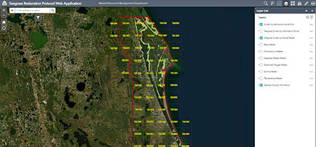
Seagrass Mapping Tool
The seagrass mapping tool is intended to aid seagrass restoration efforts by identifying the relative risks of different planting areas in the Brevard County portion of the Indian River Lagoon. The map includes overlays of multiple variables and the total suitability scores (from 6, highest risk, to 18, lowest risk). The tool does not predict outcomes, but rather aims to identify recent conditions that pose differing risk levels to seagrass survival. For a full description of the restoration protocol tool, data analysis, and risk assignment, please see the Brevard County Seagrass Restoration Protocol. Additional information on monitoring seagrasses is available in the Indian River Lagoon Seagrass Monitoring Standard Operating Procedures.
Indian River Lagoon Seagrass Monitoring Standard Operating Procedures (pdf, 3510 KB)

Manatee Field Guide Story Map
Learn the best locations to view manatees, tips for a safe viewing experience for you and the manatees, and actions you can take to help protect manatees and their home in the Indian River Lagoon.

Baffle Box Story Map
This Story Map shows the locations of all current baffle boxes in Brevard County and which entity manages them. Baffle boxes are an important part of trapping and preventing plant debris and litter from entering the lagoon. This keeps debris from decomposing into muck and harmful nutrients that feed algae blooms. Later generation baffle boxes also treat the water with special filters to remove some of the excess nutrients already dissolved in stormwater.

The Brevard County Living Shoreline Story Map
The Brevard County Living Shoreline Story Map provides information on the various types of living shorelines and benefits, plus interactive maps of shoreline data along the Indian River Lagoon in Brevard County.

Recreation Guide Story Map
Learn about the best places to explore and enjoy outdoor activities along the Indian River Lagoon in Brevard County. This interactive map will show you spots for boating access, shoreline fishing, birding, hiking, biking, paddling, horseback riding, and wildlife viewing.
Indian River Lagoon Basin Management Plan Story Map
A Basin Management Action Plan (BMAP) is a framework for water quality restoration, containing local and state commitments to reduce pollutant loading through current and future projects and strategies. BMAPs contain a comprehensive set of solutions, such as permit limits on wastewater facilities, urban and agricultural best management practices, and conservation programs designed to achieve pollutant reduction established by a Total Maximum Daily Load (TMDL).
These broad-based plans are developed with local stakeholders and rely on local input and commitment for development and successful implementation. BMAPs are adopted by DEP Secretarial Order and are legally enforceable.
